
The Mystery of Property Boundaries
When buying a new home or planning a renovation in Pretoria, one of the most common questions homeowners ask is: “How to know if a survey has been done on your property?” Many owners assume that the fences and walls they see are the official boundaries. However, physical markers can be moved or built incorrectly over time. Knowing the survey history of your land is not just a matter of curiosity—it is a legal necessity for construction, subdivisions, and resolving disputes with neighbors. We will walk you through the steps to uncover your property’s survey history and why it matters.
1. Check the Surveyor General’s Records
In South Africa, every piece of registered land has been surveyed at some point in history to create its initial “legal footprint.” The Surveyor General (SG) is the official custodian of these records.
-
The SG Diagram: This is the most important document. It shows the dimensions, angles, and coordinates of your land. If your property exists as a legal entity, an SG diagram exists for it.
-
Search Online: You can use the Chief Surveyor General’s website to search for your property using its Erf number and Township name.
-
What it tells you: The diagram will show when the original survey was done and which Land Surveyor was responsible for the work.
2. Inspect Your Title Deed
Your Title Deed is the primary proof of ownership, but it also contains vital clues about previous surveys.
-
The Diagram Deed: Look for a reference to a “Diagram Deed” or a specific SG diagram number in the text of your Title Deed.
-
Servitudes and Encumbrances: The deed will often mention if a portion of the land was surveyed specifically for a servitude (like a municipal pipe) or a subdivision.
If you don’t have your deed handy, firms like Ramatsitsi Attorneys can assist with property record searches and legal transfers.
3. Look for Physical Property Beacons
Even if a survey was done 50 years ago, there should be physical markers on the ground known as beacons. In South Africa, these are typically iron pegs or pipes driven vertically into the ground at the corners of your property.
-
How to find them: Use your SG diagram to identify where the corners should be. Beacons are often buried a few centimeters underground or hidden near fence posts.
-
Missing Beacons: If you cannot find these markers, it does not mean a survey wasn’t done; it usually means the beacons were removed or covered during landscaping or construction. In this case, you would need a Beacon Relocation service.
4. When the “Paperwork” Isn’t Enough
While the SG diagram shows that a survey was done, it doesn’t tell you the current state of your boundaries. Over decades, walls are built, and land is shifted. This is why many owners choose to commission a fresh survey.
Topographical vs. Cadastral Surveys
-
Existing Records: Only tell you the legal boundary lines from the past.
-
New Topographical Survey: Shows where your actual walls, trees, and buildings sit in relation to those legal lines. This is essential for modern architects. Learn more about the benefits of a topographical survey for your next project.
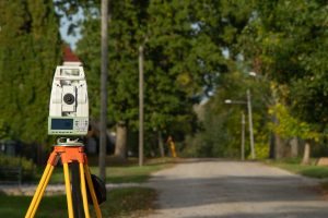
5. Why Modern Surveying is a Game Changer
If you are planning to develop your land or if there is a boundary dispute, relying on a 30-year-old diagram can be risky. Modern property surveying in Pretoria uses high-precision GPS technology that is far more accurate than the tools used in the past.
At The Land Surveyor, we often find that older surveys have small discrepancies that can lead to massive problems when building a new multi-story home or a complex of flats. For developers, a current sectional title survey is mandatory to ensure every unit is correctly registered.
6. Collaborating with Local Experts
Navigating property boundaries often involves a team of specialists. While we handle the land measurements, we recommend working with Urban Arrow for town planning and zoning. And while you manage the stress of property ownership, don’t forget to look after your health with local professionals at iMed Centre and The Family Dentist.
Summary Checklist: How to Verify Your Survey Status
-
Locate your Erf number: Found on your municipal rates bill.
-
Request an SG Diagram: Use the online portal or contact a Land Surveyor to pull the records for you.
-
Physical Search: Try to locate the corner pegs using the diagram measurements.
-
Confirm the Date: If the last survey was done decades ago, the beacons are likely missing or disturbed.
Secure Your Boundaries Today

Now that you know how to know if a survey has been done on your property, the next step is ensuring those boundaries are physically correct. Don’t wait for a dispute with a neighbor to find out your wall is in the wrong place.
Need a professional to find your pegs or verify your diagram? Contact The Land Surveyor today. We specialize in bringing property records to life with precision and accuracy.